
Diving atSite 9 (NE-1) (United States)
This dive site can feature variable sea states depending on seasonal winds, presenting conditions that divers should approach with awareness. Stronger currents are possible, particularly in deeper channels where marine life congregates. It's important to monitor local weather forecasts before planning your trip. Visibility might also fluctuate based on recent wave action or rainfall averages. Plan for potential surface chop during certain times of the year.
Starting the day at Site 9 (NE-1), the ambient air temperature is recorded at 27°C. Ongoing monitoring shows wave heights measuring 0.7 m. This data represents the current surface conditions for early activities.
Dive Site Location & Key Facts
Everything you need to know about this dive site.
Dive Site Overview
Undersea Highway, found on the southern end of Elbow Reef, is notable for its distinct parallel ledges that create an inviting underwater thoroughfare. This site features long coral fingers and sand channels that gradually slope from around 6 m (20 ft) into a deeper area.
There, the two prominent ledges, running from the northeast to the southwest, give the site its name, acting like an aquatic highway for passing marine life. Divers often position themselves in the sand to observe the activity along these deeper ledges. This particular layout makes the site accessible and engaging for various skill levels; shallow coral areas attract juvenile fish, while the deeper channels offer more to explore for those comfortable with greater depths.
Its structure facilitates an engaging dive experience, providing both extensive views and opportunities for closer observation.
Site 9 (NE-1)
Conditions are Good
Best Dive Window
Optimal conditions expected
Current conditions near Site 9 (NE-1) show 27° air, 28° sea temperature, 0.7 m waves, and 29 km/h wind. Forecast data is refreshed regularly to ensure accuracy.
Best Time to Dive
Planning a dive at this location means considering seasonal weather patterns, which significantly affect conditions. July typically offers the calmest conditions for diving, with average wave heights around 0.9 m (3.0 ft) and lower wind speeds of 25 km/h (15.5 mph). Air temperatures during this period are usually the highest, averaging around 28°C (82°F), making surface intervals more comfortable. Conversely, October often presents less favorable conditions, with average wave heights rising to over 2 m (6.6 ft) and wind speeds increasing to 33.5 km/h (20.8 mph), alongside higher rainfall, potentially impacting visibility and surface comfort. For more consistent diving, the period from May to August generally provides better opportunities with moderate wave heights (around 0.9 m to 1.2 m, or 2.8 ft to 3.9 ft) and comfortable air temperatures ranging from 25-28°C (77-82°F). Rainfall is generally low through these months, though August and September see higher averages.
PEAK SEASON SCORE
Scores combine air & water temps, waves, wind & rainfall for overall conditions.
BEST MONTHS TO DIVE
Monthly records compiled from satellite and marine observation nodes over the last 3 years. Data provided by Open-Meteo and MET Norway.
Dive Experience & Conditions
Slipping beneath the surface at Undersea Highway reveals a dynamic underwater topography. You'll encounter extensive coral fingers interspaced with sand channels, leading towards the site's deeper sections. The site's recreational depth range extends from shallower areas around 6 m (20 ft) down to about 14 m (45 ft). Water temperatures in this area are not consistently reported in available data, but typically reflect the warm air temperatures of the region, usually ranging to comfortable levels for wetsuit diving. Expect moderate currents as marine life actively moves along the ledges, which contributes to the 'highway' feel. Visibility can be excellent, though it varies depending on recent weather events and wave action, which might stir up the sandy bottom.
Dive Difficulty & Safety Guidelines
Approaching this dive requires a foundational understanding of buoyancy control and basic navigation skills. An Open Water Diver certification is recommended as the site's deepest sections extend to 14 m (45 ft). The parallel ledges running from NE to SW mean that some familiarity with underwater navigation can enhance your exploration. While no specific hazards are consistently reported for this site, divers should be mindful of currents that can occur, especially in deeper water channels. Regular monitoring of your air supply and no-decompression limits is crucial, particularly when exploring the deeper 'highway' sections. Consider diving with a local guide for optimal site orientation.
Recommended Equipment
- Dive Computer
This gear list is based on verified equipment signals for Site 9 (NE-1), United States. Always confirm final gear choices with your dive operator, guide, or liveaboard.
Recommended Dive Suit
Repeated dives during the same day can gradually reduce overall body warmth.
The water around Site 9 (NE-1) is currently holding at approximately 28°C (82°F), setting the tone for today's dives. Surface air temperatures are resting at 27°C (81°F). Divers spending extended time underwater often rely on 2-3mm shorty or light wetsuit for balanced warmth and flexibility.
The upcoming forecast points to generally steady conditions in the area.
Due to technical issues with our weather providers, data hasn't been fetched for over 48 hours. The data above reflects the conditions at the time of the last successful fetch.
Emergency & Medical Support
Essential information to help you plan your dive trip to Site 9 (NE-1).

Hyperbaric chambers are a critical part of dive safety infrastructure. Availability varies significantly by region, and not all dive areas have immediate access.
Before diving, it's recommended to:
- confirm nearest medical facilities
- check emergency procedures with local dive operators
- ensure dive insurance covers evacuation if required
Divers Alert Network
Diving emergency assistance available through DAN World.
+1-919-684-9111- 24/7 emergency hotline
- Diving medical assistance
- Evacuation coordination
Emergency contacts are provided for reference. Always verify local emergency services before diving.
Marine Life at Site 9 (NE-1)
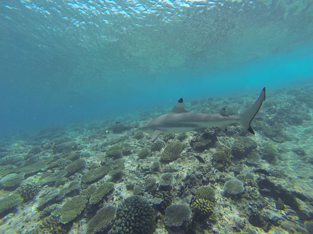
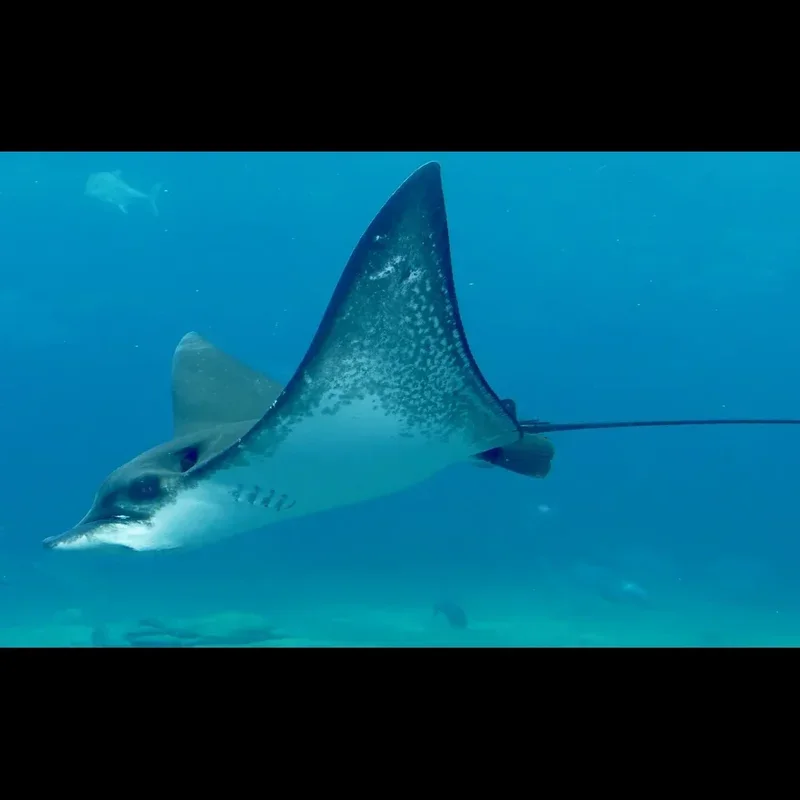
Encounters with diverse marine life define Undersea Highway, especially near its eponymous ledges. Divers frequently observe eagle rays, various schools of fish, and sharks cruising along these natural formations. A 'highway' effect reliably provides sightings of larger pelagic species moving through this thoroughfare. Shallower coral fingers also host juvenile fish and smaller reef inhabitants, making it a dynamic environment across all depths. Careful observation of the channels often reveals different species utilizing the site's distinct geological features for transit or shelter.
Dive Centers Near Site 9 (NE-1)
Working Hours
Today: 13:00 - 17:00
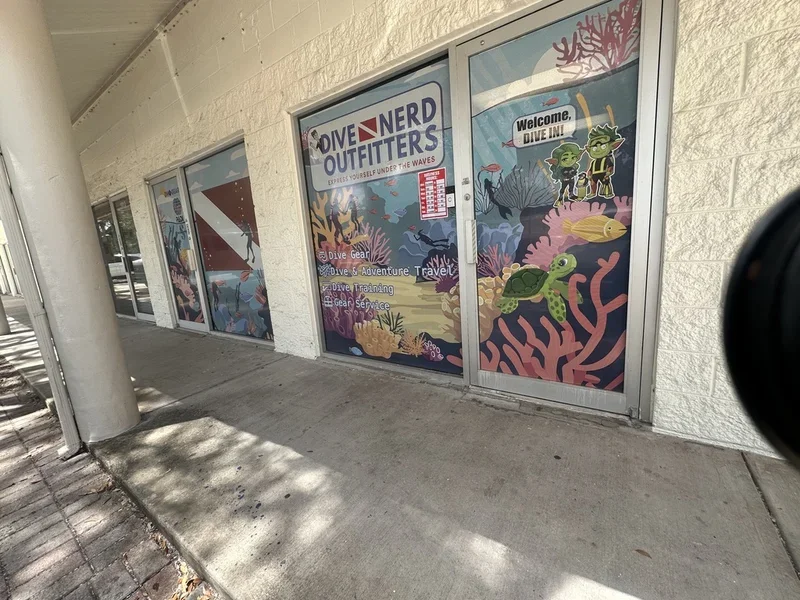
Dive Nerd Outfitters
Atlantic Pro Divers
Nearest Airports
Nearest airports to help plan travel to this dive area.
Search Flights
Check available flights and routes on Expedia, using the nearby airports listed in this section.
Search Flights on ExpediaFrequently Asked Questions
What is the maximum depth at Undersea Highway?
Maximum depth at Undersea Highway generally reaches 14 m (45 ft). Shallower sections accommodate less experienced divers, while deeper areas invite further exploration.
What skill level is required for this dive site?
Undersea Highway suits Open Water Divers. Its layout accommodates various skill levels, from those preferring shallower coral areas to divers comfortable reaching maximum depth.
What kind of marine life can I expect to see?
Anticipate seeing eagle rays, various schools of fish, and sharks actively cruising along the site's distinct ledges. Shallower coral areas also attract juvenile fish.
What are the best months for diving here?
May and July generally offer the best conditions, with calmest seas and comfortable air temperatures. While diving is possible year-round, October often brings higher waves and wind.
Why is it called 'Undersea Highway'?
It earned its name because the two prominent parallel ledges in the deeper water act as a natural thoroughfare, or 'highway,' for marine life to travel through.
Are there shallow areas suitable for new divers?
Yes, shallower coral fingers and sand channels provide excellent opportunities for new divers. Here, they can observe juvenile fish and practice skills in a less demanding environment.
Planning to dive Site 9 (NE-1)?
Send one inquiry and receive offers directly from the best verified local dive operators.
Site 9 (NE-1)
Conditions are Good
Best Dive Window
Optimal conditions expected
Current conditions near Site 9 (NE-1) show 27° air, 28° sea temperature, 0.7 m waves, and 29 km/h wind. Forecast data is refreshed regularly to ensure accuracy.